
What Clouds Produce Rain?
The clouds that produce rain are cumulonimbus and nimbostratus clouds. Stratus clouds can produce precipitation in the form of drizzle.
At any time around the world, rain is falling in the form of sprinkles, light showers, moderate rain, heavy downpours, and thunderstorms. These different types of rain come from the two different types of rain clouds that are in constant motion around the planet. Rain clouds play an essential part in the endless water cycle, including precipitation and moisture evaporation.
Precipitation and Stratus Clouds

Stratus clouds are low-level clouds generally forming below 6,000 feet. They form in uniform sheets when light, upward air currents lift a thin layer of air high enough to reach the dew point. These clouds can form as low as a few hundred feet above the ground and are shallow and cover a large area, producing fog and mist. Stratus clouds can produce drizzle, but they are called nimbostratus clouds when they produce heavy rain.
Rain and Nimbostratus Clouds
Nimbostratus clouds form a uniformly dark gray, rainy-looking cloudy layer associated with continuously falling precipitation. They generally produce precipitation that is light to moderate in intensity. They generally form below 6,000 feet and often cover thousands of square miles. These rain clouds are found worldwide but are most common in the middle latitudes. Nimbostratus clouds usually develop along a warm front and are preceded by altostratus clouds, which can turn into nimbostratus clouds. The precipitation produced by these clouds is usually steady and moderate compared to the speed and intensity of a thunderstorm. Rains could last for several days depending on the speed of the associated front.
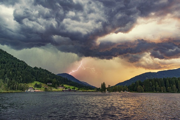
Thunderstorms

Cumulonimbus clouds are responsible for the production of thunderstorms. These are clouds that form when cumulus clouds continue to grow vertically. Their dark bottoms are often just 1,000 feet above the ground. The tops of cumulonimbus clouds can extend upward to over 39,000 feet. The taller the cloud, the more powerful the storm.
Incredible amounts of energy are released by a cumulonimbus during the storm. This buildup of energy is what causes heavy rains. When cumulonimbus clouds are associated with a cold front, the storms often come with more winds and energy. These clouds produce lightning and thunder; on occasion, hail and even violent tornadoes can develop. Cold fronts move quickly, and the precipitation falling from cumulonimbus clouds is intense but brief in duration.
Expert Opinion
“World wide, there are an estimated 16 million thunderstorms each year, and any given moment, there are roughly 2,000 thunderstorms in progress. There are about 100,000 thunderstorms each year in the U.S. alone. About 10% of these reach severe levels.”
Thunderstorm Basics National Severe Storms Laboratory
“You can estimate the distance (in miles) to a lightning stroke by counting the number of seconds between seeing the lightning and hearing the thunder, then divide by five. Just remember that lightning can come from the anvil portion of the thunderstorm and strike the ground 10 to 15 miles from the rain portion of the storm. So, just because you are estimating lightning at a distance of 2 or 4 miles away, doesn’t mean that the next strike won’t be right next to you!”
Basic Facts about Thunderstorms National Weather Service
References
New Mexico University – “Stratus Clouds”
Gavin Pretor-Pinney
The Cloudspotter’s Guide: The Science, History, and Culture of Clouds
June 2007, Perigree Trade, reprint.
Storm Dunlop
Weather Identification Handbook: The Ultimate Guide for Weather Watchers
2003, Globe Pequot, print.
UCAR NCAR Science Education – “Clouds That Make Rain”
NOAA National Severe Storms Laboratory – “Thunderstorm Basics”


