How Do Supercell Thunderstorms Form?
Answer at a Glance: Supercell thunderstorms form when warm, moist air near the ground rises and meets cool, dry air higher up—but with a twist. These storms are special because they have a rotating updraft called a mesocyclone. This rotation is caused by wind shear—winds blowing at different speeds and directions. When conditions are just right, this spinning air can grow into a violent, long-lasting thunderstorm.
🔍 Dive Deeper
- What Is a Supercell?
- The Ingredients for Supercell Formation
- How Rotation Begins
- Dangers of Supercells
- 🎯 Final Thoughts
- 📚 References
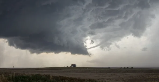
What Is a Supercell?
A supercell is a rare and powerful type of thunderstorm. Unlike regular storms, a supercell can:
- Last for several hours
- Spin and rotate
- Produce tornadoes, large hail, flash flooding, and strong winds
Supercells make up only about 10% of all thunderstorms, but they cause most of the severe weather damage in the United States [1].
🌪️ Key Feature: A supercell has a rotating updraft called a mesocyclone. This is what gives it so much energy and structure.
The Ingredients for Supercell Formation
Supercells need four main ingredients to form:
| Ingredient | What It Does |
|---|---|
| Moisture | Provides fuel for clouds and storms (usually from the Gulf of Mexico) |
| Instability | Warm air wants to rise quickly through cooler air above |
| Lift | Something to push air upward—like a cold front or dryline |
| Wind Shear | Wind changes in speed and direction with height; creates rotation |
📊 According to the Storm Prediction Center, supercells most often form when winds turn clockwise with height—a pattern called veering winds [2].
How Rotation Begins
Let’s break down how that spinning air gets started:
1. Warm, Moist Air Rises
Near the ground, warm air rises because it’s less dense. If the air is humid, it cools as it rises and forms cumulonimbus clouds.
2. Cool, Dry Air Meets It
High in the sky, cooler and drier air pushes against the rising air. This creates instability—perfect for thunderstorm growth.
3. Wind Shear Adds a Twist
Wind shear means that winds are blowing at different speeds or directions at different heights. This causes the air to roll horizontally, like a log rolling on the ground.
🌀 Turning That Roll Vertical:
The strong updraft from the storm lifts this rolling air vertically, turning it into a spinning tower of air—the mesocyclone.
Dangers of Supercells
Supercells are not just big storms—they are the most dangerous type. They can produce:
- 🌪️ Tornadoes – especially EF3 or stronger
- 💨 Straight-line winds over 100 mph
- 🧊 Hail as large as baseballs or even grapefruits
- 🌧️ Flash flooding from heavy rain
🔎 According to NOAA, about 1 in 5 supercells produces a tornado, and some supercells can spawn multiple tornadoes [3].
| Hazard | Supercell Impact |
|---|---|
| Tornadoes | Strongest, most long-lived tornadoes |
| Hail | Largest hail sizes in any storm |
| Winds | Most intense non-tornado wind gusts |
| Rain/Flooding | High risk of flash floods |
Supercells often appear on weather radar with a hook echo, which meteorologists use to spot potential tornadoes before they touch down.
🎯 Final Thoughts
So, how do supercell thunderstorms form? Supercell thunderstorms are not your average storms. They form when warm, moist air rises into a spinning, rotating updraft caused by wind shear. This creates a powerful storm capable of producing tornadoes, giant hail, flooding, and damaging winds. Thankfully, weather scientists can spot the signs early and warn people before these storms strike.
Next time you hear about a tornado watch, remember: a supercell might be behind it!
📚 References
- National Weather Service. “Supercell Thunderstorms.”
https://www.weather.gov/jetstream/supercell - NOAA Storm Prediction Center. “Ingredients for Severe Weather.”
https://www.spc.noaa.gov/faq/tornado/#Ingredients - UCAR Center for Science Education. “How Do Supercells Form?”
https://scied.ucar.edu/learning-zone/storms/supercell-thunderstorms - National Geographic. “Supercells.”
https://education.nationalgeographic.org/resource/supercell - American Meteorological Society. “Mesocyclones and Severe Weather.”
https://www.ametsoc.org/index.cfm/ams/education-careers/education-program/k-12-teachers/
📌 Learn More About Weather
- How Do Supercell Thunderstorms Form?
- Why Is It Hotter in Summer and Colder in Winter?
- Why Does It Snow Instead of Rain?
- Why Is the Sky Blue During the Day?
- What’s a Microclimate?